Trail Status - Updated 7/17/24
Trail |
Plots Fully Covered (Snow) |
Plots Half Covered |
Snow-Free Plots |
Snow on Trail? |
Plots for which Markers are Present |
Glacier Basin |
0 |
0 |
17 |
Completely snow-free except for a couple, small patches |
17/17 ALL |
Reflection Lakes |
0 |
0 |
11 |
Patchier snow after Plot 8 |
11/11 ALL |
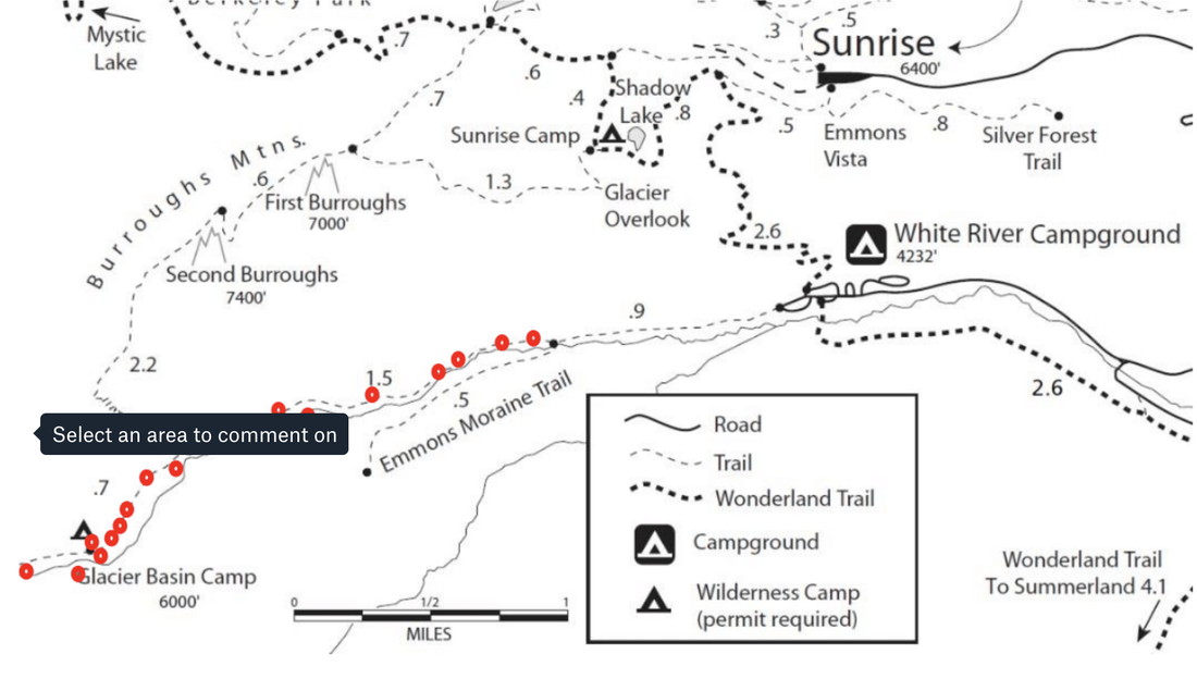
Glacier Basin Trail: July 3rdWednesday, July 3rd conditions on Glacier Basin Trail. The whole trail
is now snow free except for a very small patch within a quarter mile to the Basin. |
Reflection Lakes Trail: July 16thWednesday, July 16th conditions on Reflection Lakes Trail. The trail is
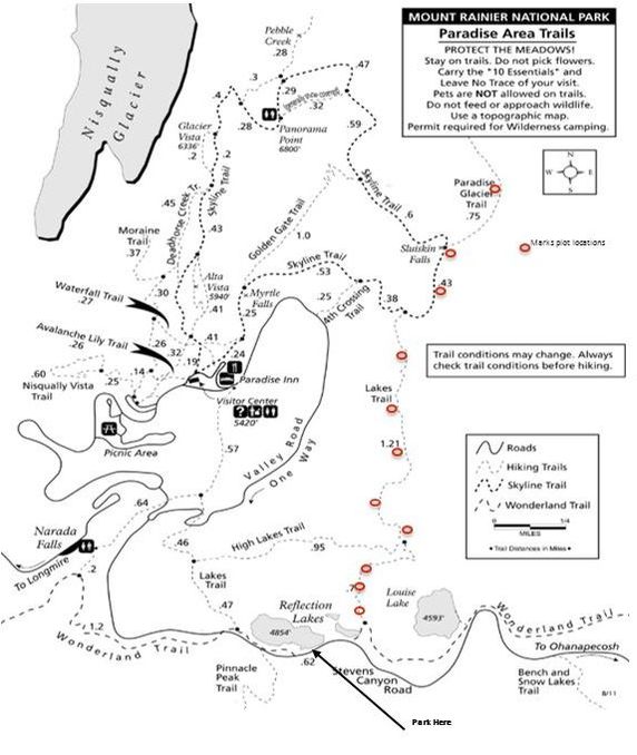
completely snow free to Plot 6, with some small snow patches onwards. Right before the junction with the Skyline trail, there is a larger patch to cross over (bottom photo), but defined tracks help show the way. Despite the tracks, we recommend having a good map to follow on AllTrails or Gaia if continuing onwards from Plot 8! |
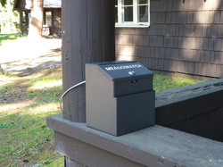 Data Drop Box on the porch of L-112
Reflection Lakes Hike
What to Expect: On the Reflection Lakes hike, you will observe 10 different wildflower species at 11 different locations along a system of trails trails that runs north to south and across approximately 2000 feet (600 meters) of elevation. The 5.5 mile round trip Reflection Lakes hike consists of the east branch of the Lakes Trail to the Skyline Trail and finally to the Paradise Glacier trail. We recommend hiking and collecting data on the way uphill as all plot descriptions in both pamphlets are written assuming this. The hike can take anywhere from 4 to 8 hours depending on trail conditions, your plant identification experience and how fast you hike.
How to Get There - Reflection Lakes: Once you are within Mt. Rainier National Park, follow the signs to Reflection Lakes/Ohanapecosh and park at the far Reflection Lakes parking lot (there are 2). Walk east along the road approximately 0.1 miles. Walk along the new granite and stoned lined sidewalk and look for signs to the Wonderland Trail. Proceed along the trail to the first plot and follow the directions in your pamphlet to the rest of the plots. Return the way you came on the trail and drive back down the mountain. Drop your data sheet on the brown metal box on the porch of L-112 (Employee Lounge) at Longmire. The Employee Lounge is directly behind the Wilderness Information Center.
Trailhead Coordinates: 46.768979, -121.724015 (You can copy and paste these into the Google or Apple Maps application on your cell phone)
Below are maps of the Reflection Lakes plots for your reference.
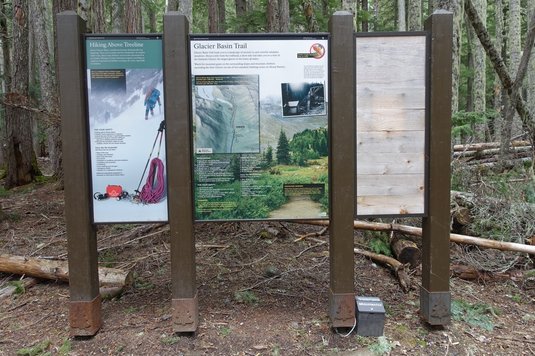 The Glacier Basin data dropbox is located at the base of the Information sign at the beginning of the trail
Glacier Basin Hike
What to Expect: On the Glacier Basin hike, you will observe 10 different wildflower species at 17 different locations along the Glacier Basin Trail, covering approximately 1300 feet (400 meters) of elevation. It is a 7 mile roundtrip hike. We recommend hiking and collecting data on the way uphill, all plot descriptions in both pamphlets are written assuming this. The hike can take anywhere from 4 to 8 hours depending on trail conditions, your plant identification experience and how fast you hike.
How to Get There - Glacier Basin: Enter the park at the east side entrance heading toward White River/Sunrise and follow the signs to the White River campground. To start your hike, park at the climber and picnicker parking lot in the White River campground, and walk through the D Loop of the campground. At the beginning of the trail, you will see an information sign about the hike and surrounding area. The brown metal box, which you can leave your completed data sheets in, is chained to the sign post on the ground. Your hike will climb approximately 1,600 feet (~500 meters) of elevation. Our directions to each plot are written assuming you will be collecting data uphill.
Trailhead Coordinates: 46.9021, -121.6437 (You can copy and paste these into the Google or Apple Maps application on your cell phone)
Below is a map for the Glacier Basin hike plots.
Naches Peak Loop Hike (There will be NO Naches Peak hikes in 2024)
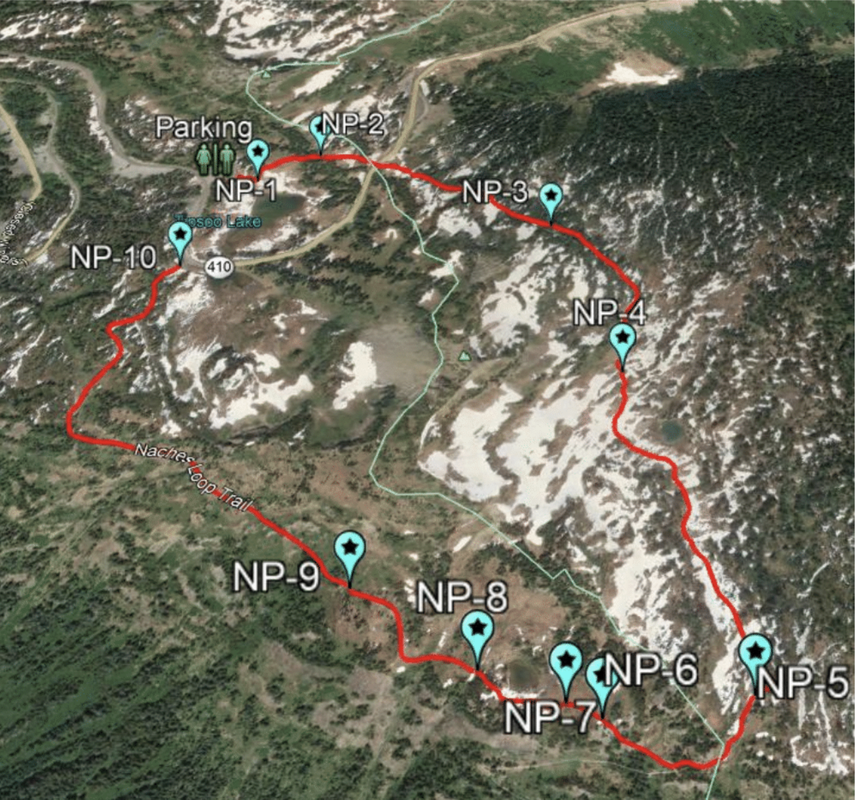
What to Expect: On the Naches Peak Hike, you will observe nine different focal species in different phenophases at 11 unmarked plots. On the hike, you will cover 3.2 miles gaining 600 feet (183 meters) of elevation and encircle the Tipsoo Lakes in the process. The plots are spread around the entire loop and the directions to each plot will need to be carefully followed to ensure success when collecting data from the unmarked plots. This hike takes about 2-5 hours to complete, depending on plant identification background and hiking speed. The data sheet you complete can be dropped off at the same location as the Glacier Basin drop-off or mailed to us at the address listed at the bottom of the webpage!
How to Get There - Naches Peak: To start your hike, park at the Tipsoo Lake parking lot. Walk towards the back of the parking lot and towards the lake (past the bathrooms and picnic tables). The trail starts between a map stand and a rock / metal memorial to Stephen Tynn Mather. Walk past a "Stay of Trail to Prevent Meadow Damage" sign, and keep left at the fork to begin the loop hike.
Trailhead Coordinates: 46.8674, -121.5176 (You can copy and paste these into the Google or Apple Maps application on your cell phone)
Below is a map for the Naches Peak hike plots.


